Albanian Alps


The Albanian Alps are a continuation of the Dinarite Mountains extending north of Albania, west of Kosovo and south-east of Montenegro. The Albanian Alps extend to the Ibar valley about 50 km in length. On the Kosovo side they rise from the bottom of the plain (500–600 m) and reach over 2,000 m, in some places cut by deep river valleys of the Peja, Decani, Erenik River and have the southern border as Drin. This mountainous group consists of several mountains: Gjeravica (the highest mountain in Kosovo 2,656 m), Junik Mountain, Strellci, Lumbardhi, Kopranik, Hajla, Zhleb, Rusolina, Mokna etc. All of these mountains exceed 2,000 m. They are steep, in the upper part are in the form of plains, where good pastures are found and skiing can be done in winter.

The Binca Morava River


The Binca Morava is a river in Kosovo. The Binca Morava originates in the Karadak Mountains (Black Mountains) on the territory of Macedonia south of Viti and north of Skopje. Two streams form the Great Stream, which when crossing the border is known as the Morava of Binca. The name was taken from Bince settlement. The Morava River of Binca flows through the Anamorava Plain through Velekinca and up to the Strait of Konculi passes through the Presevo Valley where, after 49 km of length, it joins the Little Presevo Morava near Bujanovac. The Binca Morava belongs to the Black Sea Basin. It joins the Western Morava which joins and flows into the Danube and then into the Black Sea. The entire basin of the Morava of Binca with its tributaries covers an area of ​​1,156 km2

The Ibar River


The Ibar River flows into the Albanian Alps, flows through the present-day territory of Montenegro, then through Serbia and near the Banja settlement enters the territory of Kosovo flows southeast and returns to Mitrovica flowing north through Zvecan, then Leposavic, Leshak and the foot of the Kopaonik Mountains near Rudnica emerge from the territory of Kosovo in Serbia, where on the left joins the River Rashka in the settlement of the same name, then joins western Morava and flows into the Danube and with it into the Danube. Black Sea. From its source to its outflow in western Morava it has a length of 276km, on the territory of Kosovo 82km. The riverbed is a fast-flowing mountain stream and deep bed. Expansive valleys and parts of the fast-rising mountain river and deep bed. From the source to Mitrovica the average slope of the Ibar bed is 6.7 m / km and water velocity 3.5 m / s. In the upper part the river valley is 205 m wide, at Rozaja 10 m, at Ribariq 8-15, and at Mitrovica 20-25 m. Ibri has a mixed feeding regime, namely combined with rains, melting snow and springs. It is characterized by maximum flow in March - April and minimum in August and September. While the maximum flow is related to snowmelt in early spring, the lower one is due not only to lack of rainfall but also to intensive evaporation and absorption of water in the limestone areas.

The Nerodime River bifurcation


The Nerodime River bifurcation is the only example in Europe of a river flowing into two seas. The Nerodima River flows into the Jezercian Mountains; in the vicinity of Ferizaj it is irreversibly divided into two tributaries, which spill into two different seas. The northern branch (left branch) flows into the Sitnica River and continues on the Ibar, Morava River and flows through the Danube into the Black Sea, while the southern branch (right branch) flows through the Lepenc River and Vardar into the Aegean Sea. This natural curiosity is very attractive to many scholars (geographer, geologist, hydrologist, historian), etc., and is of great educational, scientific and tourist importance. The Nerodime River bifurcation since 1979 has been put under legal protection as Special Nature Reserves.

Tomb of Sultan Murad


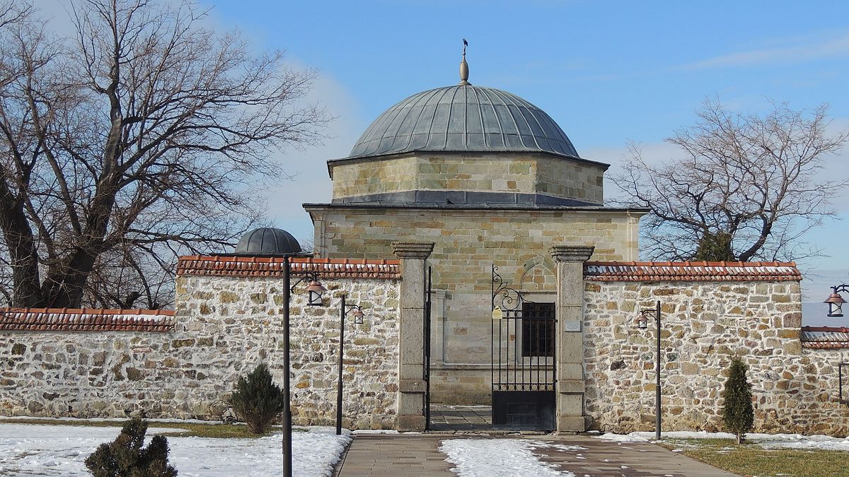
The Sultan Murat shrine is located in the Mazgit village of Obiliq. Built in the century XIV is one of the oldest works of Ottoman architecture in the Balkans. This tomb was built for the third heir to the Ottoman throne, Sultan Murat I, who fell martyred in the First Battle of Kosovo on June 8, 1389. In this tomb is the tomb of Sultan Murat (a crate worked with planks), which is surrounded by graves of persons who have preserved the tomb for decades. The layout of this building is square in shape with a brick dome, and the foreground is covered with a small dome resting on four circular pillars, formed of massive blocks of carved stone. The building has a massive masonry system: walls combined with brick-and-mortar stone walls lined with blocks of sandstone. Eight windows (on each facade of two) are installed on the walls as well as the entrance portal to the south side which ends in an arched (inner side). The drum is made of combined material: bricks on the inside and stones on the outside. The entire object on the inside is plastered to the part where the drum starts. On the outside, the entrance gate has a characteristic marble-carved decoration, featuring floral motifs and Arabic lettering inscriptions. The mausoleum records show that there were no repairs until 1660 (evidenced by Evliya Çelebi in 1660, who accompanied Pasha Melek Ahmed visited the sacred mausoleum, and noted that the tomb was neglected). In 1845 the Ottoman army commander, Hyrshid Pasha, initiated the repair of the tomb. In 1866, during the repair work on the courtyard where the well was located, a laugh was made. To provide shelter and rest for visitors to the shrine, Sultan Abdul Hamid Khan had ordered the construction of a two-storey Selamluk (inn), which was completed in 1896. In 1907, at the behest of Sultan II Abdul Hamid Khan, the shrine was renovated. . The mausoleum was restored in 2005. The restoration of the mausoleum and its annexes (works that began in May 2005 and completed within 8 months) were funded by the Turkish Institute for Religious Affairs, the Turkish Cooperation and Development Agency - TIKA and Directorate General of the Religious Foundation of Turkey. During the archaeological excavations of this phase, the old foundations of the tomb were also revealed. In 2009, as part of a project implemented by TIKA, the formerly restored Selamluk facility was converted into a crop house. Following an agreement signed with MCYS in 2010, TIKA has begun completing this complex, including completing the infrastructure needed to provide better conditions for visitors. As a result, in 2011 the mausoleum had 8,000 visitors and was one of the most visited sites in Kosovo.

Gazi Mehmet Pasha's Mosque


Gazi Mehmed Pasha's Hammam is located in the city center of Prizren near the Kukli-Mehmed Bey Mosque and Emin Pasha Mosque. It was built in 1563-74 by Gazi Mehmet Pasha, Sandzakbej of Shkodra in 1573-4. At the main gate is the inscription plate (1833) which indicates the date of the hammam's restoration by the brothers Tahir and Mehmed Pasha Rrotulli. The hammam is part of the architectural ensemble founded by Gazi Mehmet Pasha, which contains the Bayraklia Mosque, the secondary school (madrasa), the elementary school (mejtep), the library and the mausoleum (mausoleum). The hammam is a type of "hammam pairs" that is used by both sexes at the same time. It is built of different stones. The portion of the hammam for men is slightly larger than the rest for women. The hammam has all the space that the hammam has, so it consists of the entrance (waiting and for drinks), the wardrobe, the central part where washing, sweating, amusement and the boiler room located in the south of the object. The hammam is made of different stone in combination with brick. The walls are about 90 cm thick, plastered from the inside. The roof of the building has two domes built on the drum, in the cold section (reception) and nine small domes that are above the warm part of Hamam. The wardrobe and boiler part are covered with arches. The cover is tiled in the cold part, while the lead tiles in the other parts. Until 1964, Hammam was surrounded by localities, with the demolition of the premises and restoration work being started. Even in the 1970s. XX make some renovations where it is then left at the mercy of time. Since 2000 the cold part of the Hamam has been used as a gallery for organizing various cultural, artistic and educational activities. The Hammam represents one of the most characteristic Ottoman-era public buildings in Prizren, of exceptional historical, architectural, social and environmental importance.

Novo Brdo Fortress


In a small mountain between Prlepnica and Krivareka, about 30-35 km west of Gjilan and about 39 kilometers south-east of Pristina, the ruins of the medieval town and fort of Novo Brdo are preserved. According to documents discovered to date, Novo Brdo with this name was first mentioned in the early decades of the fourteenth century, under the name Nuovo Monte. The medieval town was a mining settlement and nowadays parts of walls, towers, and traces of the foundations of some of the sacred monuments of the fortress are preserved. The fortress consists of the upper town and the lower town, built on the hill of Novobrdo. The lower town, namely the Subkalaja, extends to the hills, east and southeast entirely to the mine beneath the Great Mountain. The upper town is built on the highest part of the hill, while beneath it, to the west, lies the lower town, based on the shape of a crane. The city has access only from the east. From other parts, the slope of the hill is very steep towards the valley. To the east, the terrain gradually rises and crosses to another smaller hill, on the upper plateau, beneath which are the ruins of a large medieval cathedral-style church.

Prizren Fortress


Prizren Castle contains an important part of the city's ancient history. Its topographical position, dominant over the city, very attractive natural landscape and well thought out architectural configuration make this locality with indisputable environmental, scientific, historical and tourist values. It is located in the eastern part of the city on a conical-shaped hill. The fortification walls follow roughly oval-shaped ground isohips with elongation in the north-south direction. Written sources say very little about Prizren Castle. The earliest known record is that of the Byzantine chronicler Prokopius of Caesarea in his work "De aedificiis". In this work, among the fortifications repaired in Dardania, this fortress for the first time is identified with the name Petrizen, a name that belongs to the present name of Prizren. In terms of construction it is divided into three separate complexes called: Upper City, Lower City and Southern City, while in terms of fortification through the centuries, it belongs to different periods: Ancient Period, Byzantine Period, Nemanjid Period. and the period of rule of the Ottoman Empire. A more voluminous study was made in 1969, in addition to the archaeological excavations the architectural recording of the Fortress was made. Archaeological excavations made in 1969 and 2004 resulted in the discovery of infrastructure, which is represented by walls reinforced with towers, barracks, labyrinths, warehouses and a range of objects inside. The continuation of archaeological excavations in 2004 and 2009/2011 highlighted a prehistoric settlement from the Bronze Age and early Iron Age that served as the first nucleus of life in this country. Also for the first time these excavations gave traces of architecture and evidence of dated material in the Roman period and late antiquity. During the Ottoman period, the castle was expanded by building and reinforcing fortification walls and was enriched with new facilities such as a hammam, a mosque, and other facilities for military purposes. Its last renovation was done in the third decade of the century. XIXth, from the family of the local bourgeoisie, the Rotlays. Prizren Fortress served its primary function until 1912. Since then the facility has been neglected and the process of its degradation begins. In the years 2008-2010 some restoration-conservation work is started as an emergency measure in preventing this degrading process. Prizren Castle with its dominant position in the city represents one of the most important monuments that attracts visitors to Prizren. Besides the high historical, architectural and scientific values, this locality has great economic value for the development of cultural tourism. Starting in 2010 as part of the international Dokufest Documentary Film Festival, an Open Cinema is improvised at the entrance of the Fortress where various films are broadcast, enriching the function of the Fortress with an important cultural activity.

Goddess on the Throne


"The Goddess on the Throne" is an artefact dating back to the Stone Age known in history as Neolithic. The great use of stone has given this period its name. Although dating from this time, archaeological excavations were made in the 1950s. This figurine was discovered by chance during the construction of the TERRTORJA textile factory. The figurine in question represents a female deity, reflecting the cult of the great mother idol preserved in the Pristina Museum. The Kosovo Museum has adapted the image of "Goddess on the Throne" as the logo of the special institution. Moreover, as it is one of Kosovo's most precious archaeological artefacts, it has also been adopted as a symbol of Pristina.

Ethnographic museum of Gjakova


The building is located right in the center of the city, opposite the Municipal Assembly in Gjakova. It was built in 1810 by the Sina family. The house is built on two floors p + 1. The ground floor is used as a storage room, and the upper part for housing. The living area has four rooms and two balconies. The material used is brick, stone and wood. For high decorative value, especially the large room on the left side of the building and the coals with their furnaces located in the four rooms. The corridor separates the rooms from each other and appears on the plan in the form of a cross. The house has undergone changes over time. The front had two guest rooms and a barn where the animal feed was stored. The house also had a fire house on the ground floor, while on the floor above the fire house were two auxiliary rooms that were located behind the house but do not exist today. In 1918 this house was sold by the owners and passed on as the property of Haxhi Osman Bosniak, while the Gjakova municipal assembly, through a contract with the owners, transformed it into an ethnographic museum based on the architectural values ​​and folk art of the building.

We use cookies on this site to enhance your user experience. By clicking any link on this page you are giving your consent for us to set cookies